
High-resolution and Accuracy in 30+ Countries for Utility, AEC, Energy, Insurance, and Telecoms Applications
UP42 Launches ArcGIS Pro Add-in as Part of Esri Partner Network
ArcGIS users have direct access to the UP42 platform for easier data visualization and analysis
UP42 Achieves Sustainability Partner Designation in the Google Cloud Partner Advantage Program
Google Cloud Recognizes UP42 as Part of Google Cloud Ready – Sustainability Program
UP42 Adds BlackSky Dynamic Monitoring to Marketplace
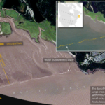
On-demand access to low-latency dawn-to-dusk imagery
UP42 Teams Up with Trimble for Faster Information Extraction from Geospatial Data

Automation to Enhance Feature Extraction, Change Detection on the UP42 Platform
UP42 Announces Thetaspace as Copernicus Masters Challenge Winner with Solution to Cloud Cover in EO Data
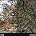
CloudlessEO Algorithm Fills in Clouds and Shadows in Optical Satellite Imagery
UP42 Unveils Very High-Resolution Imagery from Airbus Pléiades Neo Satellites

Enhancing Applications in Utilities, Insurance, Agriculture, Government
UP42 Unveils Very High-Resolution Imagery from Airbus Pléiades Neo Satellites

Enhancing Applications in Utilities, Insurance, Agriculture, Government
UP42 Teams with HEAD Aerospace to Bring Diverse Image Data to Geospatial Marketplace, Expanding Applications in Multiple Sectors

Deal makes data from 40 Chinese satellites available through UP42 now, another 40 by late 2021
UP42 Teams with Deutsche Gesellschaft für Internationale Zusammenarbeit (GIZ) GmbH to Support Agricultural Start-Ups in Africa

Strategic Collaboration to Empower Smallholder Farms with Geospatial Tech